Soil, vegetation and land use
A detailed soil mapping was performed of the provinces of Almeria and Murcia within the framework of the project LUCDEME (Lucha Contra la Desertificación en el Mediterraneo) at a scale of 1:100.000, following the classification system of the FAO (FAO-UNESCO, 1974). The most dominant soil types in the Guadalentín are Regosols, Fluvisols, Calcisols, Gypsisols and Leptosols (FAO, 2006). Leptosols dominate on the steeper slopes of the limestone outcrops, whereas Calcisols, Gypsisols and Regosols are mostly found on the flatter terrain. Calcic and petrocalcic horizons are common in these soils. The main valley of the Guadalentín is dominated by Fluvisols formed in sediments rich in gypsum and calcium carbonate and often with high levels of salinity.
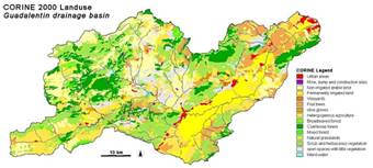
Figure 7: CORINE 2000 land use map of the Guadalentín basin. This map was extracted from the CORINE map of Spain, published by the European Environment Agency.
Vegetation in the Guadalentín is highly disturbed by centuries of human influence. Semi-natural ecosystems include shrublands with dominance of Stipa tenacissima, Rosmarinus officinalis and Anthyllis cytisoides. Forests are dominated by Pinus halepensis. The main land use in the Guadalentín at present includes under dryland conditions almonds and herbaceous crops, and under irrigation orchards with citrus, various vegetables, greenhouses and also almonds are sometimes irrigated. Figure 7 shows the CORINE 2000 land cover map for the Guadalentín basin. In this Figure, the original 44 land cover classes of the CORINE map are aggregated to 15 classes. The map shows important areas of irrigated crop concentrated in the main valley of the lower part of the Guadalentín. The headwaters are dominated by dryland farming, open spaces, scrub and forest cover. On the false colour satellite image of Figure 2, some additional irrigated crop areas can be distinguished visually by the red appearance. However, it should be realised that land use is quite dynamic and that important changes have taken place in recent years, and are ongoing, especially in the surface area of irrigated crop.
