Institutional and political setting
The most important drivers of land degradation are the ones that affect land use, land management, and climate characteristics (Gobin et al., 2004). The most relevant drivers of land degradation in the Guadalentín basin are agriculture, water availability, human population, tourism, transport, climate, and land use subsidies. Changes in either of these drivers can either positively or negatively affect land degradation in the basin.
There is a range of policy instruments meant to act against land degradation. Most of them focus on vegetation cover or land use and management changes through the use of regulation and subsidies. For example, the Rural Development Policy Regulation provides funding from the European Agricultural Guidance and Guarantee Fund (EAGGF, 1257/99) to establish new rural development plans based on Good Farming Practices (GFP). The GFP contain valid national standards for tillage, alternate crops and the use of fertilizers among other aspects. These standards can be modified by regional governments to suit local requirements. Examples of national agrarian regulation based on EU Common Agricultural Policy (CAP) legislation are (adapted from: Rojo-Serrano, 2004):
- Maintain set-aside arable land. In Spain, set-aside of 10% is compulsory and an additional 10% can voluntary be set-aside.
- Maintain traditional fallow land under minimum tillage or an adequate vegetation cover in order to minimise erosion risk.
- Prohibition of tillage following the slope direction.
- Prohibition of tillage in vineyards, olive groves and nut plantations on slopes steeper than 15%, except when soil conservation practices (e.g. terraces, protection strips, conservation tillage, complete soil cover) are adopted.
- Nut production (e.g. almonds, walnuts, hazelnuts, etc.) is subsidised per hectare of land.
A further instrument of policy development is reforestation of degraded and agricultural lands. Its objectives are to enhance long-term forest resources and to combat soil erosion and desertification. Program implementation is the responsibility of the Autonomous Communities, but is also co-financed by the central administration and the EU through the EAGFF.
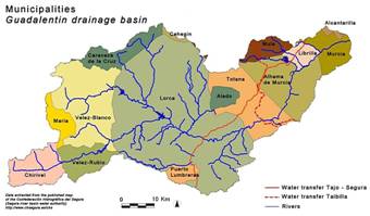
Since measures to combat land degradation are related to several sector policies such as agrarian, nature conservation and environment, hydrology, urban and rural development, coordination of effective policy is extremely complex (Rojo Serrano, 2004). Moreover, the Guadalentín basin is divided over the provinces of Murcia and Almería, and so over two of Spain's autonomous regions (i.e. Murcia and Andalucía). The basin forms part of fifteen municipalities (Figure 9). Many soil erosion and conservation issues are administered by different institutions within the Ministry of the Environment (Dirección general para la Conservación de la Naturaleza, DGCONA), at national and regional level, and by the basin authority of the river Segura (Confederación Hidrográfica del Segura, CHS). Although policy decisions are taken at many different levels, most of the decisions and policies at these levels are constrained and initiated through regulation provided by the CAP of the EU.
Since joining the European Community (EC), the Spanish agricultural policy has been dominated by the CAP, whose priority is the development of sustainable and ecologically-sound agriculture. However, CAP implementation in southern Mediterranean European countries, and particularly in Spain, has had contradictory effects on soil erosion (e.g. set-aside resulted in a strong increase in the extent of bare soils vulnerable to erosion) (Rojo Serrano, 2004; Boellstorff and Benito, 2005). CAP reforms, in the context of Agenda 2000, signified a new era of integrated development of rural areas, including soil protection and erosion control.
Figure 9: Overview of the municipalities within the Guadalentín basin.
Reforestations and forest administration originally were under the responsibility of the Hydrology and Forest Divisions that was founded in 1901. However, increasingly responsibility for forest resources and nature conservation has been transferred to autonomous communities. The central government, through the Ministry of the Environment, co-ordinates plans and programmes related to soil protection and desertification control. This includes the Spanish Forestry Strategy (EFE), the National Forest Plan (NFP) and the Autonomous Forest Plan. Objectives include the design of new forestry policies, emphasizing multiple uses of forests, organization of forest resource responsibilities within the central administration, co-ordination with autonomous administrations and renewal of forest activity as a means of generating employment and economic activity. The Forestry Strategy, developed by the NFP, promotes reforestation of degraded plant cover areas, wildfire protection and application of silvicultural treatments to improve forest quality.
When Spain signed the UN Convention to Combat Desertification (CCD) in 1996, it was committed to establish a National Action Programme to Combat Desertification (NAPD). This is being prepared by a working group co-ordinated by DGCONA of the Ministry of Environment, with the main objective to promote sustainable development in Spain's arid, semiarid and dry sub humid areas, to prevent and reduce land degradation, and to rehabilitate degraded land. In this framework, in 2002 DGCONA initiated a national inventory of soil erosion (INES) which aims to locate, quantify and analyse the evolution of erosion processes in Spain. The main objectives are to prioritize target areas for soil conservation and define and evaluate national plans on reforestation, plant cover improvement and the management of forest biodiversity. In every province an inventory and map (1:50.000) will be made of rill, gully, river bank and wind erosion and mass movements. The inventory maps of the province of Murcia have been completed. The inventory will be repeated on a cyclical basis.
