Past and ongoing projects in the Guadalentín
Previous projects
Assessment of land degradation in the Guadalentín basin has been accomplished in a variety of past research projects. Beside publication of study results in a vast amount of scientific journals, several book chapters have been dedicated to describe the context of land degradation and review parts of the work done in the Guadalentín (e.g. López-Bermúdez et al., 1998; Lopez-Bermudez et al., 2002; Romero Diaz et al., 2002). Four large past European research projects with a focus on land degradation and desertification in the Guadalentín basin are:
- MEDALUS I, II, III (ended 1999): MEDALUS was a project of 3 phases with the overall objective to evaluate and analyse land degradation processes in the Mediterranean in the context of global change (i.e. land use and climate). The Guadalentín was one of the focus areas during all project phases.
- MEDACTION (ended 2004): MEDACTION adopted an integrated, multi-disciplinary approach, involving social- and natural scientists as well as the principal stakeholders in the study regions to: a) develop land use change scenarios at various scales, b) analyse effects of past policies in four target areas, c) analyse the costs of land degradation and benefits of mitigation measures, d) develop options for land use policies, mitigation strategies, and incentives to combat desertification.
- DESERTLINKS (ended 2004): The main aim of this project was to contribute to the work of the United Nations Convention to Combat Desertification by developing a desertification indicator system for Mediterranean Europe.
- RECONDES (ended 2007): The RECONDES project focussed on the assessment of landscape connectivity and the use of vegetation cover to reduce erosion and sediment transport from hillslopes to river channels. In the Guadalentín the work involved monitoring of vegetation and geomorphic changes in the Rambla de Torrealvilla.
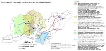
Figure 10 provides an overview of the study areas where most work was done in the Guadalentín, as well as some examples of published studies and their main focus. Obviously, not all studies are mentioned in this figure, but we consider that it reflects reasonably well the kind of work that was done within the drainage basin. Most studies are clearly bounded in space, although some studies have a more general character and are not limited to a specific study site such as the studies about the changing socioeconomic situation and the stakeholders perception of land degradation (Romero Diaz et al., 2002; Juntti and Wilson, 2005; Oñate and Peco, 2005).
It is clear from Figure 10 that there has been a large variety of studies in the Guadalentín. Most of them have focussed on the description, monitoring and modelling of physical aspects underlying land degradation processes. The various studies have significantly contributed to an increased understanding of land degradation processes, their effects as well as the socioeconomic drivers of land degradation. Although partial implementation plans to solve specific problems have been carried out (e.g. reforestations and construction of check-dams for flood control and to mitigate sedimentation in reservoirs), no global integrated implementation plans have been designed yet to mitigate land degradation in the Guadalentín. Moreover, no comprehensive evaluation has been performed of previous implementation measures to mitigate land degradation in the Guadalentín basin, except for a study of the effectiveness of check-dams and reforestation in the Sierra de Torrecilla (Castillo et al., 2003). So, there is limited knowledge of which measures have been or are successful and which are not with respect to soil conservation and mitigation of land degradation in the Guadalentín.
Figure 10: Overview of the main study areas and the type of studies performed in the Guadalentín basin during the last decades.
