Step 1
Step 1: Defining applicability limitations of each technology
The WOCAT Technology Database (based on the Technology Questionnaires completed in WB3) presents data on the technologies that can be considered for each study area. A technology may have several basic requirements that must be met for it to be implemented. The purpose of this phase is to rule out any part of a study area that is not suitable for the application of the technology being evaluated. Limitations as meant here are physical constraints, rather than factors reducing expectations that the technology will be cost-efficient. For example, it is not possible to construct terraces on steep slopes with shallow soils. Only when all applicability limitations of a technology are satisfied can the technology be applied in a certain area. Currently, the following options are available to define applicability limitations:
- Soil depth interval: the rootdepth input layer for PESERA is used as a proxy)
- Slope gradient interval: this can be extracted using the 'Slope' tool from Arctoolbox to extract slopes from a Digital Elevation Model (DEM)
- Landform: landform can be defined based on existing landform maps, or alternatively by using the 'Curvature' tool from Arctoolbox which extracts curvature from the DEM. Convex areas are shoulder areas whereas concave areas are footslopes. A subsequent operation is needed to distinguish between plateaus and valley bottoms, which both are characterised by low or zero curvature values
- Land use: the model uses the simplified legend from the CORINE land cover mapping project proposed for the PESERA land use input data layer (Irvine and Kosmas, 2003). Where necessary the more specific original categories of CORINE can be used. Even more detailed local land use categories may be used as long as they are coded as further subclasses of the CORINE land cover classes. The maps to be constructed under WB1 are the preferred source, although a conversion process to match CORINE land use legends may be necessary.
- Temperature: currently an interval based on average annual temperature (constructed as the average mean monthly temperature of the twelve monthly rasters used as input for PESERA) can be specified
- Precipitation: currently an interval based on total annual precipitation (constructed as the sum of mean monthly precipitation of the twelve monthly rasters used as input for PESERA) can be specified
- Distance to stream: from the DEM, a drainage network can be constructed using the 'Flowdirection' and 'Flowaccumulation' tools from the Arctoolbox and subsequent distillation using Map algebra. To improve the quality (hydrological correctness) of the DEM, a "fill sinks" operation can be applied. Alternatively, a drainage network digitized from maps or aerial photos can also be used. Either way, a buffer operation can be applied to specify the maximum distance to streams required by a certain technology
- Depth of groundwater: currently not implemented due to lack of data, but if an input layer is available this criterion can be considered as well
- Combinations of the above criteria can be considered by querying the relevant layers (optional)
For each technology, each of the above criteria will result in an output map showing the applicability in a dichotomous fashion. Only raster cells where all conditions are met will finally be classified as the applicability area for the technology considered. Where maps of conservation areas (WB1) have been prepared that identify areas already treated with specific technologies, those can be used to refine the potential applicability area.
Data sources: WOCAT Technology Questionnaire (TQ); PESERA model input data; DEM of the study area (e.g. SRTM 90m); WB1 maps of conservation efforts; optional additional input data.
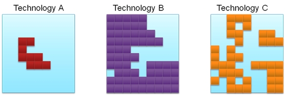
Intermediate product: Raster layer showing the potential applicability area of each technology (for a schematic example, see figure 3.2).

Figure 3.2: Hypothetical applicability areas for three technologies