Phase 3
Phase 3: Linking land use and human agents
This part of the modelling framework links long-term trends in the management of agro-ecosystems, as indicated by the observed land uses, with those who are managing land within this system. It aims to capture interactions between human agents and their environment. As such, this part of the analysis will shed light on how the socio-economic characteristics of the land managers/users have constrained their land use decision making, which in turn has shaped the overall pattern of agro-ecosystem management over the years. This kind of understanding has the potential to form a basis for making forecasts about future trends in agro-ecosystem management in the area.
In principle, the approach used in this phase follows the preceding phase in that land use maps produced in phase 1 provide one of the main inputs for the analysis. However, in this phase it is not the spatial but the socio-economic characteristics of the agents that are treated as the explanatory variables. Two forms of 'relationship' will be investigated between the characteristics of the agents and their: 1) dominant land uses; and 2) land use diversity (captured by standard diversity indices such as Shannon's diversity index) across the land (s) managed by these agents. The dichotomy arose from preliminary site visit observations that a land manager/farmer could have more than one agricultural land use. To obtain the socioeconomic data of the human agents for this modelling, semi structured interviews are presently being carried out targeting up to 100 farmers, including those 30 farmers/land managers participating in the interviews in Phase 1. The observed spatial land use patterns, historical (result of phase 1) and current (with the addition of solar panel for example), forms part of the basis for selecting these interviewees. The primary target land managers/farmers of the study are those who have been managing land or farming in the area from at least 2004; although the available land use map stretches back to as early as 1956.
A semi-structured questionnaire has been devised and was trialled towards the end of 2008 in the study area. The resulting questionnaire is currently being administered by a professional interviewer. To date, 30 interviews have been completed with good data coverage. The interview captures the following information:
- The characteristics of land tenure, employment status and off-farm income of the interviewees;
- Data on land use decisions on individual parcels of land including reported past and recent changes as applicable;
- Economic data relating to land management;
- Data on actual and potential application of soil and/or water conservation measures on the lands that the interviewees own and/or manage. The purpose of this section is to find out an array of factors that may encourage or otherwise deter farmers from adopting particular soil and water conservation measures. As part of this exercise, the interviewees were also presented with a set of hypothetical financial incentives to see how future external assistance may increase the likelihood of certain measures to be adopted especially for those that were considered by the interviewees for being too costly to install and/or to maintain;
- Water access for agricultural production;
- Data on labour requirements; and
- Demographic information about the interviewees and their household: age, gender, education, household composition, and the availability of a successor to take over the management of the land when the interviewees retire.
One section of the interview is designed to explore how land managers/owners/farmers would respond to future scenarios that are deemed relevant for future policy making. This is further elaborated in section 4.1.5. In brief, these scenarios are contained in the following three broad categories:
- Change in EU subsidy scheme under the CAP;
- Regulation of water access & water pricing; and
- Environmental change.
These selected scenarios were informed by literature and concerns that farmers raised during the two stakeholder workshops organised as part of WB3 in Spain during February and June 2008. Based on this set of scenarios, future change in land use patterns within the study area can be empirically and realistically unravelled.
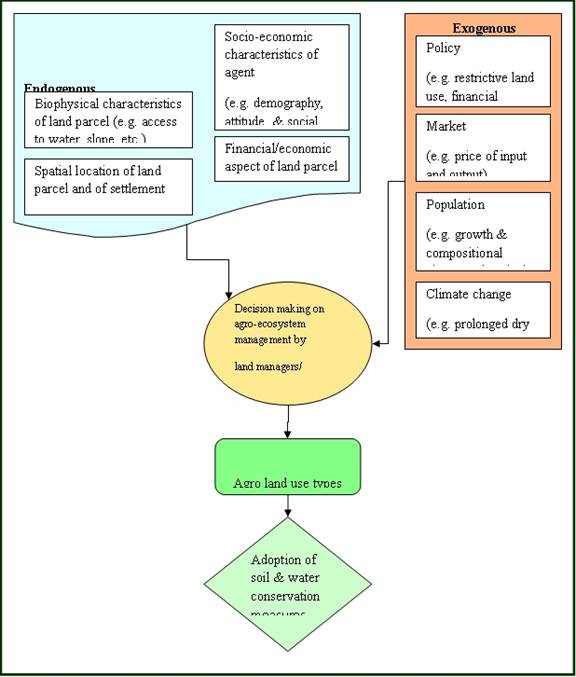
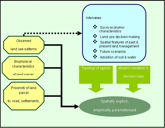
A behavioural choice model will be estimated using data from the questionnaires and used to characterise land use decision making. The model outcome shall highlight a range of the characteristics that have a significant effect on their respective agro-ecosystem management decision making. These significant characteristics form the building blocks of the algorithms for decision making rules for the Agent Based Modelling (ABM). Figure 4.3a provides an overview of land use decision making as influenced by an array of factors while Figure 4.3b depicts a simplified model framework for the ABM. Using the spatial information of the land being managed by each of the land managers/farmers, the ABM is made spatially explicit taking advantage of the GIS extension available in NetLogo.

Figure 4.3a: The dynamics of land use decision making in dryland agro-ecosystem management in south-eastern Spain

Figure 4.3b: Agent Based Modelling framework of dryland agro-ecosystem management in south-eastern Spain